from Tech-Economic Times
via IFTTT
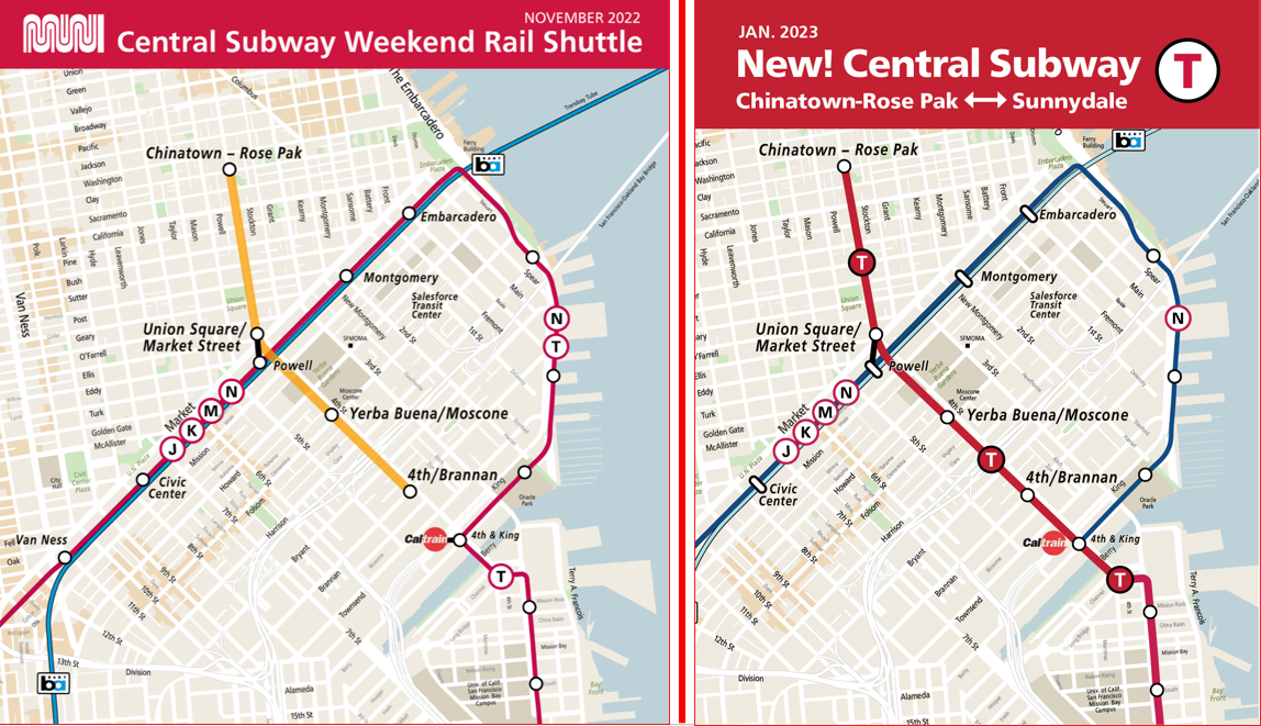
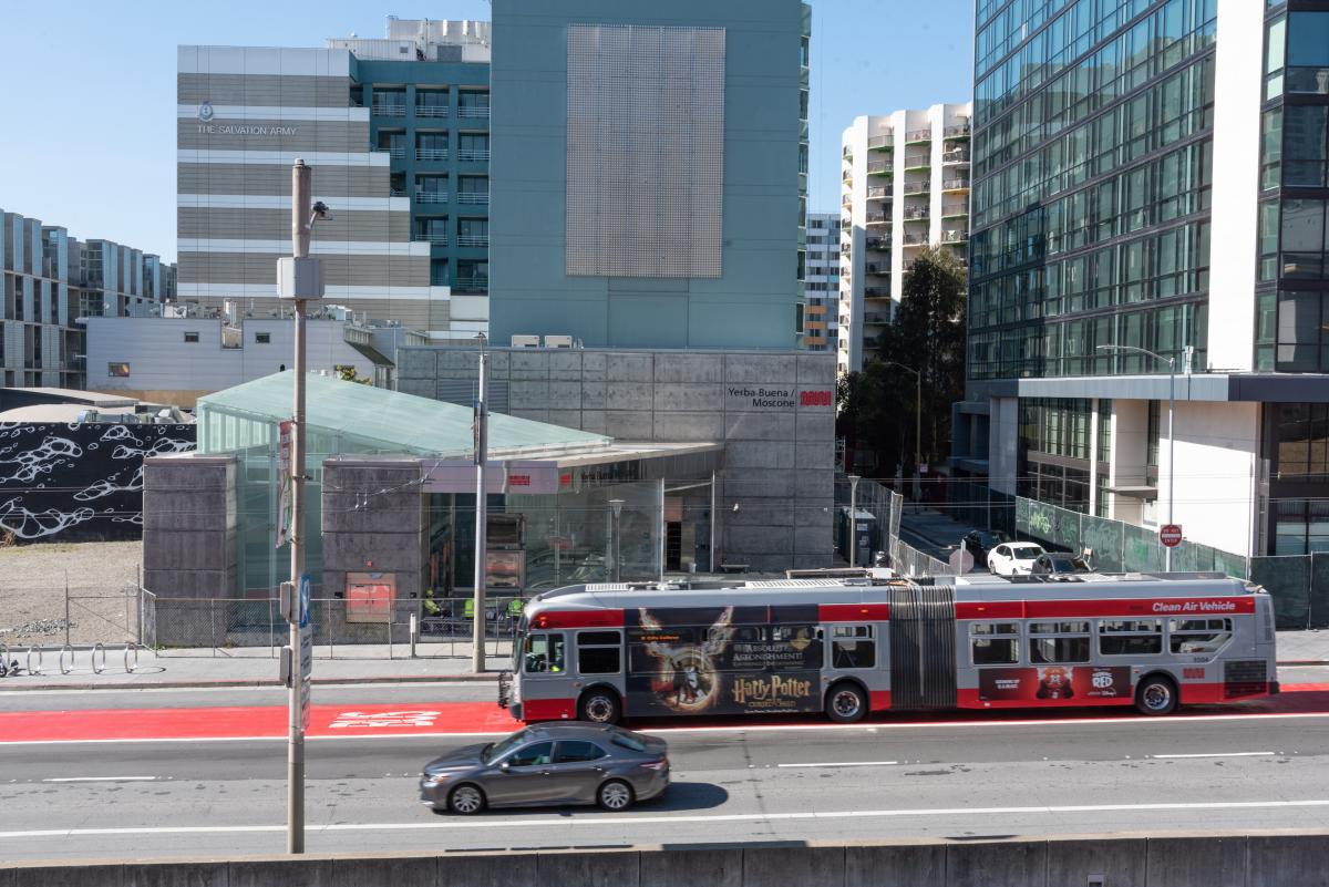
Earlier this month, we launched free weekend shuttle service in the Central Subway. And come January 7th, our 4 new stations will connect directly to the rest of the T line from Sunnydale to Chinatown. Through this two-part blog series, we will look back at some of the history of the T from the 1860s to today!
In Part One, we’ll look over the first 150 years from the 1860s to the 2000s. Next month in Part Two, we will take a closer look at the history of the T and Central Subway projects leading up to today’s service.
The Horsecar Era: 1860s-1890s
Starting in the 1860s, transit service along today’s T Line was provided by horsecars. These were small rail cars (that looked much like a cable car) that were pulled along tracks by horses. Two companies, the Omnibus Railroad and the North Beach & Mission Railway, operated horsecar lines on parts of the path of today’s T. These lines were mainly meant to connect North Beach with the 3rd and 4th street corridors as far south as about Townsend Street.
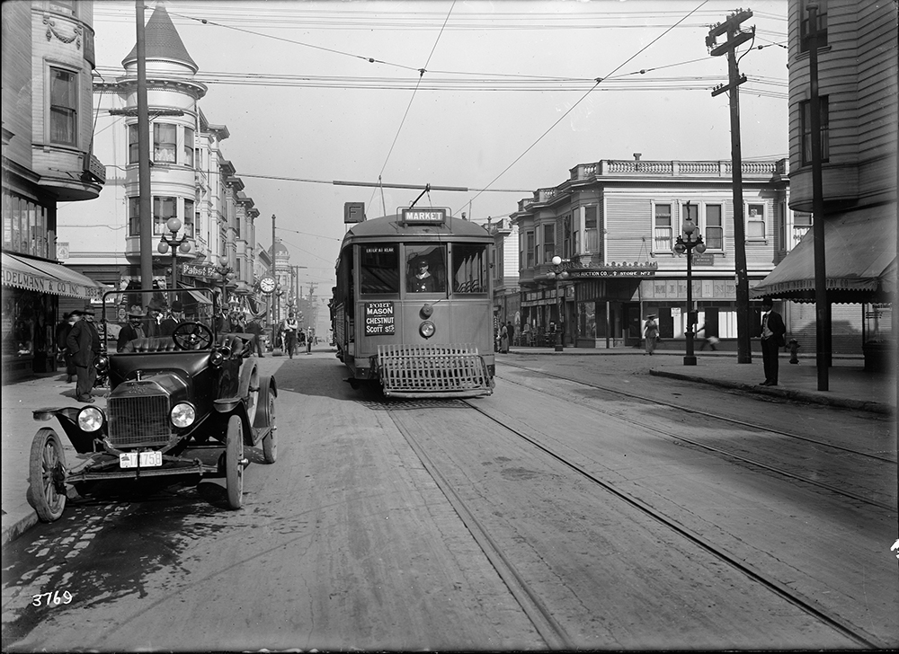
This photo circa the 1880s shows the busy intersection of Kearny, Geary, 3rd and Market streets, looking south to 3rd. In the foreground is a horsecar running up Kearny from 3rd.
Further south on 3rd (then called Kentucky Street), horsecars were operated by the Potrero & Bay View Railroad. Here the route ran over two bridges across Mission Bay and Islais Creek (known as “Longbridge”), ending near today’s 3rd & Gilman. This route served the industrial heart of San Francisco and opened up development in the Bayview but was not very profitable because of its length.
The Electric Streetcar Era: 1890s-1940s
The 1890s marked the dawn of the electric streetcar era in San Francisco. A new technology, electric-powered cars could carry more people over longer distances faster than both horse and cable cars. On top of that, they were cheaper to operate and increased profit potential for transit companies.
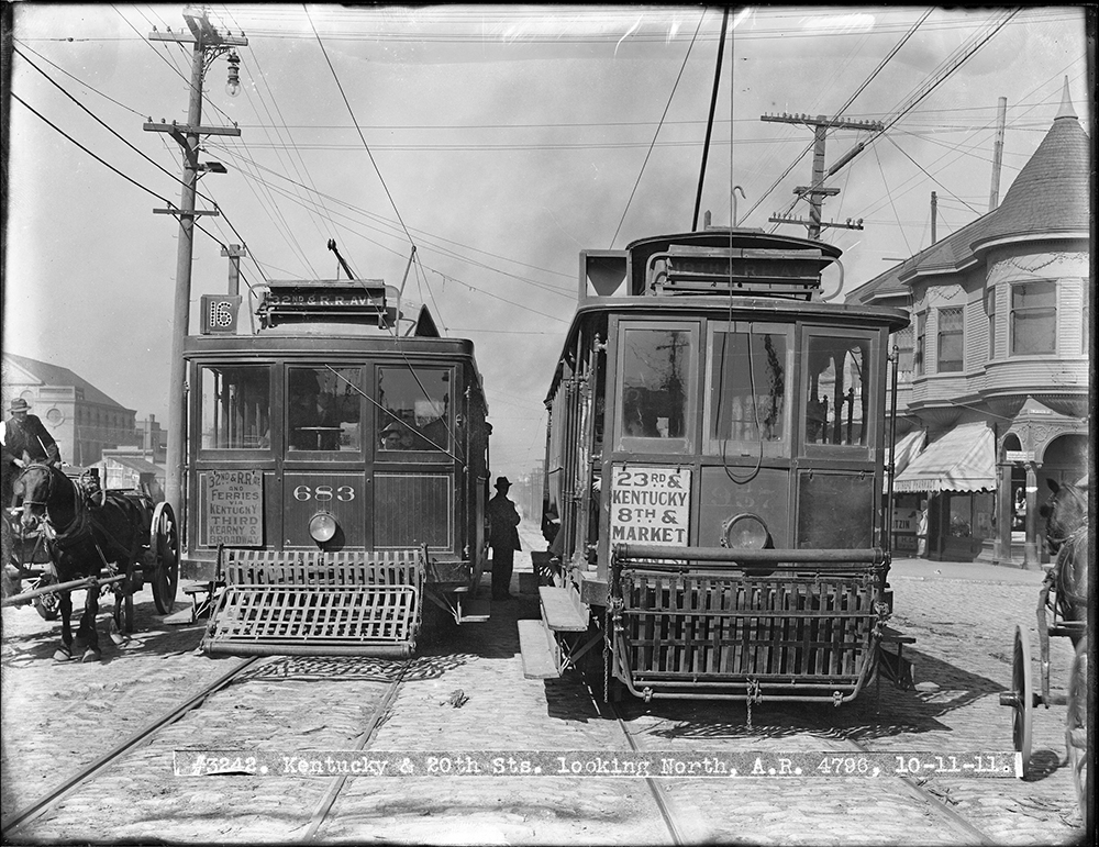
This 1911 photo shows two cars passing at 3rd (Kentucky) and 20th streets. On the left is a 16 Line car running to its terminal in the Bayview. At right is a 30 Line car heading north to 8th and Market.
In 1894, the first electric streetcar line began operating along parts of today’s T Line. Known as the 3rd & Kearny Line, it followed much the same route as the early horsecars from North Beach to the Southern Pacific Railroad Depot on Townsend Street. It was extended into the Bayview to 3rd and Palou and eventually was reformed into the 15, 16, and 29 Lines. Each of these served a different portion of the corridor covering differing needs of riders travelling through downtown or all the way out to the Bayview.
A Muni F Stockton streetcar passes Vallejo Street in this photo from 1916.
Muni’s first streetcar line to serve a similar route to the Central Subway portion of the T was the F Stockton, which opened for the 1915 Panama Pacific Exposition. The F Line ran along 4th and Stockton streets to serve South of Market, Union Square, Chinatown and North Beach before heading out to end at Chestnut and Scott streets.
Buses along the Bay: 1950s-2000s
Following World War II, the 3rd Street corridor was among the many that saw transit service shift from streetcars to buses. By 1951, the 15 Kearny route served much of the area once covered by the 15, 16, and 29 streetcar lines.
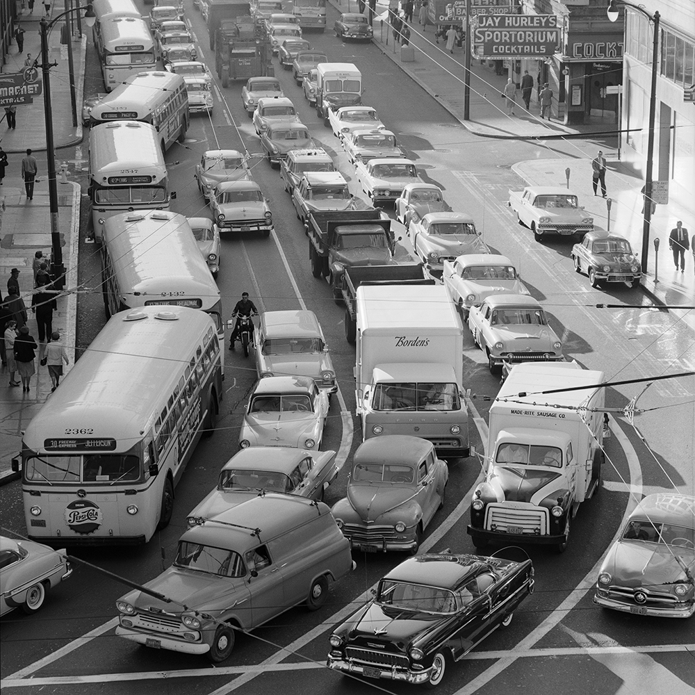
Buses on the 30, 15 and 42 fight the morning rush northbound on 3rd Street in this 1959 photo.
Traveling along portions of today’s 8 Bayshore and T Third, the 15 route went from Powell and Jefferson streets all the way to Geneva and Mission. Eventually, it was extended to City College on Ocean Avenue. While not the only route to serve the area, the 15 carried the bulk of the load for people wishing to travel along this corridor.
On Stockton Street, the 30 Stockton bus took over for the F, following the same route through Chinatown, Union Square, and South of Market to 4th and Townsend streets.
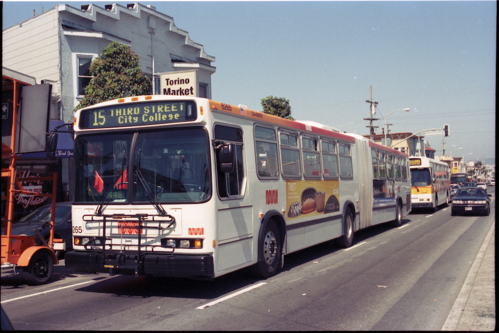
Many long-time riders will recognize this view of a 15 bus on 3rd & Palou. Discontinued with the opening of the T Line in 2007, the 15 was revived as the 15 Bayview-Hunter’s Point Express in 2021.
Tune in next month for a closer look at the history of the T Third and Central Subway Projects.
Rendered image of the completed Battery/Sansome Quick Build Project
The first-ever protected bike lane in the Financial District is on its way in!
This week, SFMTA crews are starting work on the Battery/Sansome Quick-Build project. Approved by the SFMTA Board of Directors in September, this project will bring a two-way protected bike lane to Battery Street. The project will also add pedestrian safety improvements on both Battery and Sansome Streets, and some loading changes on Battery.
This project is a major step forward for cycling in the city. Apart from the Embarcadero, there is no other protected bike lane near the Financial District — even though two out of the 10 most active bike share stations in the city are in the downtown area. With so many people returning to downtown offices after working from home due to the pandemic, this new route will offer a safer option for those looking for a more active commute.
Over the past year, SFMTA staff have worked with neighborhood stakeholders to come up with a design that meets current needs and supports downtown San Francisco’s future. During the same time, the Downtown SF Partnership — the neighborhood’s nonprofit that supports local businesses — commissioned a plan to imagine how the neighborhood could evolve out of the pandemic. Downtown was hit especially hard by COVID-19 and has been slow to recover. The Downtown SF Public Action Realm Plan makes a number of recommendations for activating the neighborhood, from more greenery to improved public spaces. The plan also calls for creating better bike connections and a safer, more welcoming pedestrian experience throughout the neighborhood. The Battery/Sansome Quick-Build project was named in the plan as an essential part of transforming Downtown SF into a more welcoming space for all.
During our outreach, we heard a lot of enthusiasm for the idea of a two-way bike lane, which is now being built on Battery Street. But we also heard concerns that removing a vehicle travel lane could worsen congestion in the downtown area, especially during peak commute hours when people head toward the Bay Bridge. To address these concerns, the western side of the street will have commercial loading zones that local businesses will be able to use except for during peak hours, when the zones will need to be cleared. That way, the street will still have three functional vehicle travel lanes during rush hours. This solution was designed with the community to keep traffic flowing while creating a dedicated space for active travel.
Construction will likely take up to three weeks, and we appreciate your patience as these important street improvements are completed. By early next year, the Battery/Sansome Quick-Build will be open for use to explore all that Downtown SF has to offer. As you’re riding through, make sure you stop to admire the new mural at the Battery Bridge by Peruvian-born, SF-based painter Talavera-Ballón — and share what you think of the new bikeway with our team.
For more information and updates, please visit Battery/Sansome Quick-Build Project.
Central Subway special weekend service shuttles customer between Chinatown-Rose Pak Station and 4th & Brannan to explore the new stations. And on January 7, T Third service will connect from Chinatown-Rose Pak to Sunnydale.
What has four brand new stations, thousands of curious customers and really long escalators? It’s Central Subway! Special weekend service launched Saturday and Sunday, November 19 and 20 with a steady stream of Muni customers excited to experience the SFMTA’s historic new subway. They were greeted by ambassadors in orange giving out fortune cookies and Muni squishy trains and answering lots of questions. Customers got to see the new Central Subway stations for the first time and start to learn how to navigate new connections with special shuttle service operating between Chinatown-Rose Pak and 4th & Brannan stations.
We know this is a big change for everyone and it will take time to adjust. As we ready for the official launch of the new T Third line from Chinatown-Rose Pak to Sunnydale on January 7, 2023, we are making final preparations, like installing and updating signage and other improvements over the coming weeks. We are also taking steps to respond to customer feedback we heard over the weekend. Here are some of the most common questions we heard.
To get the answers to these and other frequency asked questions, visit our service changes page (SFMTA.com/ServiceChanges) and click on the Central Subway Service FAQs.
And please remember, safety first! Always stay behind the yellow lines on the train platforms.
Over the past two years, Slow Streets have shown how simple designs that prioritize people can transform streets. Suddenly, streets across San Francisco filled with the sounds of kids playing and neighbors chatting. They filled with people on bicycles and people rolling in wheelchairs; with joggers and dog-walkers. The streets came to life.
Initially, the SFMTA introduced Slow Streets as an emergency response to COVID-19. People needed space for recreating at a safe distance outdoors. And with Muni service reduced or suspended at the time, people needed ways to travel to essential destinations on foot or bike. To quickly meet these early pandemic needs, we implemented Slow Streets with simple signs and barricades.
Over time, it became clear that Slow Streets served an even larger purpose. They became places for communities to come together. Neighbors organized events like scavenger hunts and Trick or Treat parties around their local Slow Streets. They created art and hosted pop-up musical performances. For many people, Slow Streets encouraged them to shift their lifestyles. Some families sold their cars and began to travel by cargo bike. Older San Franciscans rediscovered the joy of riding bicycles. Fleets of kids gathered to bike to school in organized “bike buses” across the city. Beyond the initial pandemic response, Slow Streets proved critical to meeting some of San Francisco’s most significant goals: Vision Zero and Climate Action.
As the city moves out of the pandemic, it’s clear that Slow Streets have a place in San Francisco. We need to continue to encourage active transportation to meet our goal of 80% low-carbon trips by 2030—and we need to make these trips safe and accessible for people of all ages and abilities. Low-stress streets, like Slow Streets, create transportation choices for a wide range of San Franciscans by making active transportation comfortable, safe, and joyful.
On December 6, our Slow Streets team will bring a proposal for an ongoing Slow Streets program to the SFMTA Board. This post-pandemic program will maintain the same core principles as the pandemic-response Slow Streets. Its goal is to create safe, shared corridors that prioritize people traveling by active modes and making local trips by vehicle. But it will improve on the COVID-response program in some key ways. The proposed program will have a more durable, diverse design toolkit that will include traffic calming features like speed humps, traffic diversion, roadway narrowing, and improved wayfinding signs. And it will use data to make sure that streets are working effectively.
Our goal is for Slow Streets to meet or exceed national standards for low-stress corridors: streets where people of all ages and abilities feel comfortable walking and biking. That means no more than 1,500 vehicles per day, and speeds lower than 20 mph. For each Slow Street, our team will develop a design that reflects specific needs and conditions. We will also gather and analyze data on important safety measures like vehicle volumes and speeds, and adjust designs when needed. We aim to work efficiently and in collaboration with communities to implement these corridors.
Following the meeting on December 6, we will be sharing updated guidelines for using Slow Streets—whether you bike, roll, walk, or drive. These guidelines will create shared understanding for how to behave on Slow Streets to make sure everyone feels safe and welcome. More to come on this soon, but in the meantime, remember: Everyone is welcome, and please go slow!
Initially, we’ll be proposing 15 corridors for inclusion in the program. Most of these streets were COVID-Response Slow Streets that met criteria for continuing them as Slow Streets: high volumes of people walking, biking and rolling, and connections to the citywide active transportation network. Proposed Slow Streets are:
Lake Street, which was already approved as a long-term Slow Street by the SFMTA board, will also be discussed by the board at the December 6 meeting. Existing Slow Streets that are not approved by the SFMTA Board will be removed following the meeting. While the Slow Streets in SoMa are not recommended to continue as a part of the ongoing program, the existing traffic calming and local access restrictions will remain in place to encourage the use of these streets as places for community activation.
This is just the beginning of a program that we intend to grow to meet neighborhood and citywide transportation needs, in partnership with communities. An ongoing Slow Streets program for San Francisco will help our city meet its adopted goals for mobility, safety and climate action—and ensure that San Franciscans can continue to reimagine how their streets can serve them. We look forward to beginning this process and sharing more in the future.
For more information, please see the Slow Streets Fall 2022 Project Update and Frequently Asked Questions.
Today, our new taxi meter rates go into effect, providing a much-needed increase for taxi drivers. After extensive outreach, the SFMTA board passed an 18% increase in the taximeter rates – the first increase in 11 years. During this time, the cost of living in the Bay Area has risen considerably.
The new rates listed below will support an industry that is an integral part of our transportation system, especially for SF’s paratransit program.
The new rates go into effect beginning Thursday, November 17:
For more information on the current structure of taxi fares, please visit Taxi Fares.
To get a sense of what this increase will mean for an average rider, we show an estimate for a typical taxi trip.
Under the old rate structure, the average cost for a taxi ride was $16.04, which includes a 15% tip. Under the new approved structure, the average cost, including tip will be $18.98, or a $2.94 increase per trip. This increase goes directly to taxi drivers.
Impact on Paratransit Taxi Riders
Taxis have been an integral part of the SFMTA’s paratransit program since the 1980’s, and they provide an important mobility option for people with disabilities who are unable to use Muni. The SFMTA subsidizes 80% of the cost of paratransit taxi trips, and the paratransit taxi rider pays the remaining 20%. Paratransit taxi riders will see an increase of approximately $0.50 for an average paratransit taxi trip under the new meter rates. Paratransit taxi trips accounted for roughly 13% of all taxi trips in the last fiscal year.
Please contact SFTaxi@sfmta.com with any questions you may have about the new rates.
Starting November 19, Central Subway opens for special service, allowing customers to experience the new Yerba Buena/Moscone Station.
The new Yerba Buena/Moscone Station at 4th and Folsom streets along the Central Subway connects Muni customers with the communities and attractions in San Francisco’s South of Market district. The new station is located across the street from Yerba Buena Square and the Moscone Convention Center and steps away from hotels, museums, shopping and restaurants. However, you choose to spend your time in Yerba Buena, you’ll have no shortage of things to do.
Interested in the arts and culture? Yerba Buena/Moscone Station is your stop! Explore the San Francisco Museum of Modern Art (SFMOMA), the Contemporary Jewish Museum, the Yerba Buena Center for the Arts, the Museum of the African Diaspora (MOAD), the American Bookbinder’s Museum or the Children’s Creativity Museum, all within a couple blocks.
Smartphone users can also take the Yerba Buena Public Art Audio Walking Tour – a self-guided experience curated by the Yerba Buena Community Benefit District that explores the diverse public art in the area. Or visit the California Historical Society to learn more about our great state.
Forgot what it’s like to go to the movies? Catch a new film – maybe in 3D – at the Metreon, just blocks from the new Yerba Buena/Moscone Station. Or gather friends for a more active experience at the Yerba Buena Ice Skating and Bowling Center.
Casual and fine dining restaurants, hip coffee shops and both trendy and classic bars abound throughout the area around the Yerba Buena/Moscone Station. Or opt for a picnic at the Yerba Buena Gardens.
San Francisco City College students and faculty will also be able to take the T Third and get off at Yerba Buena/Moscone Station to get to the downtown center campus on 4th and Mission.
Going shopping? The Yerba Buena/Moscone Station puts Muni customers close to the Westfield Shopping Centre, big box stores like Target and the Container Store on 4th Street, and food hubs like Trader Joe’s and Whole Foods.
The Yerba Buena area of SoMa is also the thriving cultural hub of the Filipino community in San Francisco. For a unique experience, visit Arkipelago Books – a cornerstone of the Filipino community in SoMA for 20 years. Follow the Public Art Walking Tour to Lapu Lapu and learn more about Filipino history and key figures of the community.
At the Yerba Buena/Moscone Station, Muni riders can easily transfer to several nearby Muni lines to get around the city!
Connect to these SoMa destinations when you hop on Central Subway’s special weekend service starting Saturdays and Sundays, November 19, from 8 a.m.-12 a.m.
For those who wish to connect from Yerba Buena/Moscone Station to other locations around the city, several bus routes that are within walking distance of the new station including the 8 Bayshore, 8AX Bayshore Express A, 8BX Bayshore Express B, 15 Bayview Hunters Point Express, 30 Stockton, 45 Union, 91 3rd Street and 12 Folsom.
Get to know the new Central Subway destinations with special weekend service through the end of year. Then, on Saturday, January 7, kick off the new year with new T-Third service via Central Subway between Chinatown and Sunnydale. Fall in love with San Francisco all over again!
SFMTA will switch over to a new, upgraded software system on Sunday, November 13, as part of our Next Generation Customer Information System (CIS) project. The new software was developed to improve the way our different information systems communicate with each other and share data to and from multiple sources. This will provide customers more accurate, timely, reliable Muni service predictions. This is one more important step in the overhaul of our CIS that will enable us to provide better service to Muni customers.
SFMTA’s Next Generation CIS software has been in preliminary testing for months, and if all works well, Muni customers should not notice any change. But anyone who’s had to help loved ones with computer or smartphone troubles knows that software updates aren’t always smooth. Unanticipated challenges may arise. Customers should expect some glitches as we make the software switch and work out issues on the back end.
To reduce impacts to customers, we are gradually connecting new screens to the new software system. This should help isolate any issues to troubleshoot more effectively. Our Customer Information System staff and software contractors will be keeping a close eye on system performance and working quickly to resolve issues.
This upgrade to a new, more efficient software system is a crucial milestone toward providing many new features over the coming months, including:
Third Party Apps
SFMTA provides open-source transit data that third party transit apps use on their platforms. Each app has its own way of processing that information, which can vary and may lead to differences or inconsistencies in transit information. SFMTA is in touch with known third party apps to help them troubleshoot issues.
We appreciate Muni riders’ patience as we continue our Next Generation CIS upgrades to improve Muni service long-term.
Central Subway special weekend service will be running just in time for the holiday lights at Union Square
The new Central Subway Union Square/Market Street Station puts Muni customers in the heart of historic San Francisco, beneath Union Square Plaza at Geary and Stockton streets – open just in time to enjoy Macy’s famous holiday window displays and ice skating on the plaza.
Surrounding the Square, visitors can access world-class shopping from some of the most coveted names in fashion and jewelry. Travelers will be steps away from several big-name and boutique hotels. Quaint locally owned cafes, delis, restaurants and bars nearby offer a wide variety of cuisine from Asian to French to Irish, and beyond!
Barbary Coast Trail markers on the sidewalk will lead you on an odyssey through old San Francisco. Maiden Lane – a polite reference to the activities that once took place in the early days of the city – is now a stylish pedestrian promenade only half a block north of the new station entrance. Take a stroll and you’ll even see one of Frank Lloyd Wright’s buildings there.
Architecture buffs will find even more to explore around Union Square, where the skyline is sprinkled with Beaux-Arts, Chicago style, Art Deco, Futurist, modern and contemporary construction.
A short walk further north leads to the famous Chinatown Dragon Gates on Grant Street, marking the entrance to the neighborhood where San Francisco’s growth from tiny outpost to booming city began. Learn more about the destinations near Chinatown-Rose Pak Station..
Head to Powell Street, one block west of the Union Square/Market Street Station entrance and catch the Powell/Hyde or Powell/Mason Cable Car lines to ride America’s only moving National Monument! Read more about San Francisco’s cable cars and their unique history.
Historic cable cars run along Powell Street, next to Union Square.
Connect to Union Square when you hop on Central Subway’s special weekend service starting Saturdays and Sundays, November 19, from 8 a.m.-12 a.m.
T Third service between Chinatown-Rose Pak Station and Sunnydale starts January 7, 2023. Read more details on our service changes page.
Ever wonder about the effectiveness of projects after they go into the ground? Us, too!
That’s why, in 2017, we launched the Safe Streets Evaluation Program to help project teams understand whether a transportation safety project’s design is effective, and where there might be opportunities to adjust the design if not. Project evaluation data can also be combined across projects to help the SFMTA track the effectiveness of a certain type of safety improvement, which can in turn streamline the design of future projects. The Safe Streets Evaluation Program helps us work towards achieving Vision Zero, an initiative to prioritize street safety and eliminate traffic deaths in San Francisco.
This week, we’re looking back on five years of data gathered through our Safe Streets Evaluation Program with the “2022 Safe Streets Evaluation Summary,” an interactive website summarizing the results of 18 bicycle, pedestrian and traffic safety projects implemented since 2017.
Each of the 18 projects evaluated in the summary report added significant safety upgrades to the streets. Some introduced vehicle travel lane removals (road diets), separated bikeways, separated bike signals, or left-turn traffic calming devices. Others brought general improvements for pedestrians at intersections including pedestrian signal improvements, daylighting (red zones at intersections) and upgraded crosswalks. For every project, the SFMTA drew on a wide range of data—from project-specific observations, to police reports, to speed data—to create a comprehensive view into its’ effectiveness.
The evaluation report indicates that the SFMTA’s safety tools are working together to create safer environments for all modes of transportation on city streets.
You can dig into the whole set of outcomes on the website, but here are some highlights:
Within the projects evaluated, annual collision rates decreased by 18%
Bicycle-related collision rates decreased by 33% and pedestrian-related collision rates decreased by 32%
Bicycle volumes on streets that received bicycle improvements increased up to 75% in the morning peak (8 AM to 10 AM) commute times, with similar growth in the afternoon/evening peak (4 PM to 6 PM) commute times.
Thanks to protected bikeways, the rate of incidents of vehicles blocking the bike lane decreased by 90%.
Close calls or near misses between pedestrians and drivers decreased across evaluated projects by 38%.
Several projects in under-served communities such as the Bayview and Tenderloin are helping to address historic inequities and under-investment in these neighborhoods.
The Safe Streets Evaluation team will continue to think creatively about how to build on the evaluation work and use it to inform our current and future projects, programs, and practices through developing a publicly accessible database of all Safe Streets Evaluation data and finding better ways to evaluate project outreach efforts.
View the 2022 Safe Streets Evaluation Summary
Learn more about the SFMTA Safe Streets Evaluation Program: SFMTA.com\safestreetsevaluation